Thunderstorms swept across London on Monday afternoon, transforming what began as a warm summer day into a dramatic weather crisis that brought flash flooding, transport disruptions, and public safety concerns. The storm, marked by intense rainfall and hailstones, arrived swiftly after midday and led to major challenges for Londoners trying to navigate the city during the evening rush hour.
The IFS Cloud Cable Car, London’s only urban gondola, was suspended after lightning risks intensified. Roads turned into shallow rivers, vehicles stalled, and parts of North and East London experienced localized flooding severe enough to halt public transport services and reroute buses. This sudden shift in weather came after the capital reached a relatively balmy 24°C earlier in the day, catching many off guard.
A Storm Descends: Timeline of Events
Hail and Torrential Rainfall
By early afternoon, ominous clouds began forming over Greater London. Meteorological alerts had been in place since midday, with a yellow thunderstorm warning issued by the Met Office covering London, parts of western England, and areas of Wales. The warning cautioned about the potential for localized flooding, lightning strikes, and travel disruptions.
Around 3:30 PM, conditions deteriorated rapidly. In several districts, hailstones as large as marbles pelted streets and vehicles. Within moments, heavy downpours flooded roads and clogged drains. In some neighborhoods, particularly in Shoreditch and Hendon, streets became impassable.
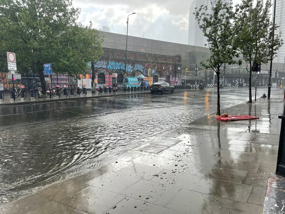
Flooding Hits Major Roads
In North London, the Hendon Way (A41) became one of the first major thoroughfares to succumb to flooding. Water levels rose between Wessex Gardens and the Brent Cross Flyover, leading to its temporary closure. This vital arterial road, used by thousands daily, was shut down entirely, forcing Transport for London (TfL) to divert bus routes and redirect traffic.
Brick Lane, in Shoreditch, was similarly overwhelmed. Eyewitnesses reported water rising to the base of parked cars in under 10 minutes. Shops and residential entrances were partially submerged, and pedestrians scrambled for cover. Some areas saw floodwaters reach as deep as an inch or more, accumulating debris and straining London’s aging stormwater infrastructure.

Cable Car Closure: An Unusual but Necessary Measure
The IFS Cloud Cable Car, a unique feature of London’s transit network spanning from North Greenwich to the Royal Docks, was shut down just after 5:00 PM. TfL confirmed that the suspension was due to “a high lightning risk in the area.” The move followed safety protocols designed to prevent the risk of electrocution and ensure passenger safety, particularly in systems elevated and exposed to open air.
Cable cars are sensitive to severe weather conditions, and operations are often suspended if lightning is detected within a certain radius. While closures due to wind are more common, lightning-related shutdowns are rare and indicate the severity of the storm system over the Thames Peninsula.
Emergency Response and Public Safety
Transport Disruption and Bus Diversions
As water pooled on streets, TfL implemented multiple diversions for affected bus routes. Commuters in North and East London faced delays, with many buses avoiding flood-prone roads entirely. In areas like Finchley and Kilburn, traffic slowed to a crawl. Emergency services worked quickly to clear blocked storm drains and guide traffic away from affected zones.
Some London Underground services were delayed, particularly on surface-level lines like the Overground. While no stations reported full closures, several lines experienced minor interruptions due to water intrusion on tracks or signal faults caused by electrical disturbances.
Advisories and Warnings
The Met Office issued guidance alongside the yellow thunderstorm warning, stating the likelihood of spray and sudden flooding, which could cause road closures and difficult driving conditions. Local councils used social media to urge residents to avoid driving through standing water and to stay indoors unless travel was absolutely necessary.
The London Fire Brigade, already experienced in dealing with flash floods in previous summers, remained on alert. While no major rescues were reported by the end of the day, several basements in Hackney and Islington reported water ingress, prompting localized fire service responses to pump out water.
Meteorological Analysis
The Nature of Flash Flooding in Urban Environments
Flash floods differ from regular flooding in that they occur within minutes to hours of excessive rainfall, particularly in areas with poor drainage. London, with its vast swathes of concrete and limited permeable surfaces, is especially vulnerable. When storm drains reach capacity or become blocked by debris, water has nowhere to go, resulting in rapid surface flooding.
This kind of event is exacerbated by intense, short bursts of rainfall like those observed on Monday. Streets designed for gradual runoff become overwhelmed, and low-lying areas are the first to bear the brunt.
Heavy hailstone shower in London this afternoon. #weather pic.twitter.com/4aZEiGspif
— Jason Rodrigues (@RodriguesJasonL) May 12, 2025
Climate Trends and Urban Vulnerability
Events like these are becoming more frequent in London due to climate change. Meteorologists have warned that warming temperatures are increasing the frequency of short, high-intensity rainfall events. Urban planners have noted that without investment in better drainage, green infrastructure, and flood-resilient architecture, London will remain at risk.
Research from the London Climate Resilience Review suggests that while Thames Barrier upgrades protect against tidal surges, surface flooding remains an under-addressed threat. Monday’s storm highlighted these vulnerabilities once again.
Forecast for the Week Ahead
Despite Monday’s chaos, the storm marked a brief interruption in what is otherwise a warming trend. The Met Office has forecast a return to sunny conditions beginning Tuesday, with temperatures rising to 26°C. High pressure is expected to dominate for the remainder of the week, bringing dry, settled weather across southern England.
While a return to sunshine is welcome for many Londoners, meteorologists warn that future storms could strike again with little notice. The public is encouraged to monitor real-time updates from the Met Office and TfL when severe weather warnings are in place.
Broader Implications for Infrastructure and Policy
Strain on Urban Systems
London’s infrastructure is largely designed for historical climate norms. Victorian-era sewers, narrow streets, and limited green space contribute to the city’s struggle with extreme weather. On days like Monday, it becomes clear that retrofitting the urban fabric for future resilience is no longer optional—it’s essential.
The city has made strides, with projects like the Thames Tideway Tunnel underway to improve sewage overflow capacity. However, these projects target river pollution rather than surface flooding. Advocates are calling for additional investment in surface water management strategies, including rain gardens, permeable pavements, and upgraded drainage systems.
Role of Local Authorities
Local authorities played an essential role during the storm, coordinating emergency responses, closing roads, and providing updates. Boroughs like Camden and Hackney were particularly responsive, using social media and council websites to alert residents about affected zones and provide flooding safety tips.
Moving forward, councils will likely review the effectiveness of their response and update their flood preparedness strategies. Funding from central government for resilience programs remains a point of debate, especially as councils face increasing financial strain post-COVID.
Public Awareness and Preparedness
One takeaway from the storm is the importance of public awareness. Many residents were caught off guard, unprepared for the rapid change in weather. Enhanced communication from the Met Office, local councils, and transportation authorities is critical in reducing risk during such events.
Public campaigns about the dangers of driving through floodwaters or walking across submerged paths are increasingly necessary. As the city adapts to a new climate reality, so must its citizens.
Human Impact and Eyewitness Accounts
Residents React
Residents in affected areas described scenes of confusion and disruption. In Hendon, one commuter noted, “It felt like the heavens just opened up in minutes. One moment it was sunny, the next we were surrounded by water.” Another Shoreditch resident shared photos on social media of submerged bicycles and water entering storefronts on Brick Lane.
Local businesses in East London reported minor property damage, with some cafés and shops having to close early as water threatened to seep inside. Insurance claims may rise slightly in the coming days as homeowners and business owners assess damages.
Vulnerable Communities Hit Hardest
Historically, flash flooding tends to disproportionately affect lower-income areas and public housing blocks located in low-lying districts. While Monday’s storm did not result in widespread evacuations, communities with limited mobility or those living in basement flats faced heightened risk.
Advocacy groups continue to urge local government to prioritize flood defenses and early warning systems for these high-risk populations.
Conclusion: A Wake-Up Call for London
Monday’s thunderstorms were more than just an inconvenience—they were a stark reminder of London’s fragility in the face of extreme weather. As climate patterns shift, these events are likely to become more frequent, and the costs—in terms of infrastructure damage, economic disruption, and public safety—will rise.
The closure of the IFS Cloud Cable Car, while symbolic, highlighted the extent of the storm’s reach. Meanwhile, flooded roads like the Hendon Way demonstrated the real-world consequences of underprepared infrastructure. From transit systems to storm drains, London’s resilience is being tested.
While the capital is expected to return to sunny and warm conditions in the days ahead, the storm should not be forgotten. It’s a call to action for policymakers, engineers, and residents alike to rethink how this great city prepares for the future.

- Natural Lip Filler – Elegant Lip Enhancement & Subtle Lip Augmentation - December 19, 2025
- Lip Augmentation in London – Lip Filler London & Natural Lip Enhancement - December 16, 2025
- Bonnie Blue secretly filming huge C4 show which will reveal ‘what her life’s really like’ after 1,000 men sex stunt - June 5, 2025